|
To
get to the west side of Vancouver Island, from Victoria, take
Hwy 14 to Sooke and then northwest to the end of the road, which
is at Port Renfrew. This small quaint settlement is located at
the mouth of the San Juan River and Port San Juan. Port Renfrew
is the southeast end of the Pacific Rim National Park's West Coast
Trail. This trail is a 77km (45.5mi) hike along the coast of Vancouver
Island. This is typically west coast, with wet weather and lush
forests. This whole area is heaven to hikers, hunters, anglers
and beachcombers. When in this area , take in the Botanical Beach
Provincial Park. Go at low tide, to see the intertidal life. It's
also a good place to view the Pacific grey whales. And by taking
logging roads from Port Renfrew you can travel to Cowichan Lake.
Click
here for a list of accommodation/adventure providers in this area.
North
of Duncan, take Hwy 18 to Lake Cowichan. This long partially paved
road cuts through from the east to the middle of the island and
beyond to the west coast. Lake Cowichan has excellent trout fishing,
From Lake Cowichan Village at the east end of the lake, the road
splits. The road along the north shore leads to Yoobou and a logging
road to Bamfield. The south shore road leads to Port Renfrew.
Around Lake Cowichan's shore is a network of nature walks. The
Cowichan Valley Demonstration Forest , located along the lake,
on Hwy 18, provides an outdoor classroom of forest management.
Click
here for a list of accommodation/adventure providers in this area.
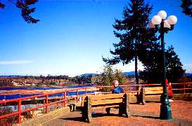
Ladysmith
is 85km (53mi) north of Victoria on Hwy 1. It was the home for
coal miners who worked the Extension Mines and draws it's name
from Ladysmith, South Africa. In the 1930's the mining changed
to forestry and now tourism is increasing in importance.
The
downtown core has spruced up its image by restoring the heritage
buildings, adding art galleries, gift and antique shops. Take
a walk along the natural deep harbour where you can enjoy fishing,
swimming or just relaxing.
Click
here for a list of accommodation/adventure providers in this area.
 Located
on Stuart Channel, just east of Hwy 1, 78km (46.5mi) north of
Victoria is Chemainus. Located
on Stuart Channel, just east of Hwy 1, 78km (46.5mi) north of
Victoria is Chemainus.
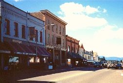
In
the early 1980's, the town was on a decline due to the closing
of the sawmill. With the help of local artists , it became "Canada's
largest outdoor art gallery". The 32 large murals,
painted on downtown walls, depicting the history of the area,
are more than just a local attraction. It's said that over 250,000
people from far and wide come to see these murals. The tourist
trade has given Chemainus the economic jolt it needed.
Click
here for a list of accommodation/adventure providers in this area.
This
out-of-the-way salmon fishing centre is on the southeast side
of Barclay Sound. During the summer the population increases from
275 to about 2,000 people, as sports fishermen use it as a base
to fish Barclay Sound and Alberni Inlet. Many others come to hike,
scuba dive and canoe. This small community is well equipped to
handle the increased population during the summer. The village
of Bamfield itself is unique, as only one side of the Bamfield
Inlet is accessible, walkways and trails are along this one side.
The inlet is used as a highway. To reach Bamfield, take the unpaved
road 102km (43.5mi) south of Port Alberni. Or, from Youbou on
Lake Cowichan, take the 108km (66.5mi) unpaved road west. From
Port Alberni you can take the Lady Rose.
|

 Ladysmith: